About WWF Nautical Chart
The app can be used to pinpoint your location in Wismar Bay and the Bay of Greifswald It also shows the particularly sensitive areas and boating rules in the voluntary agreements within the Natura 2000 areas. Users, e.g....
The app can be used to pinpoint your location in Wismar Bay and the Bay of Greifswald It also shows the particularly sensitive areas and boating rules in the voluntary agreements within the Natura 2000 areas. Users, e.g. people who are fishing, sailing, motor boating, kite-surfing, rowing, kayaking or canoeing, can see on their smartphone or tablet at any time whether they are inside or outside protected areas. It is no longer a valid excuse to say you don’t know where you are!
The app is designed to help you comply with the BOATING RULES. Improved navigation on the water will reduce disturbances in the protected bays and in the breeding and resting areas of waterbirds. It is intended to help ensure that people and nature can co-exist in harmony in the species-rich coastal waters.
Interesting information about NATURE is provided for individual areas and the legal regulations are also available for anyone who wants to know more.
HOW THE APP WORKS
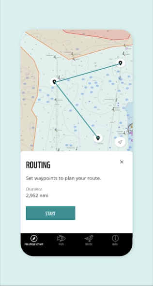
Navigate through the Wismar Bay and the Bay of Greifswald using the routing function. Waypoints make it easy for you to avoid the protected areas.
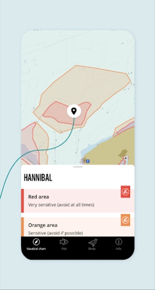
Click on the red and orange zoning or colour-coded protected areas to learn more about nature and special regulations.
The “Nature” section contains a glossary with explanations of protected areas, regulations and institutions.
In the “Fish” section you can find useful information about fishing, including a description of individual fish, fishing seasons, minimum sizes, periods closed to fishing and the Red List status of the individual species.
The “Bird” section features common birds with photos and audio.
Detailed maps can be downloaded under “Info” and then “Nautical charts”.
FEATURES:
- Waypoints can be set with the routing function. The distance and course of the selected route are automatically displayed.
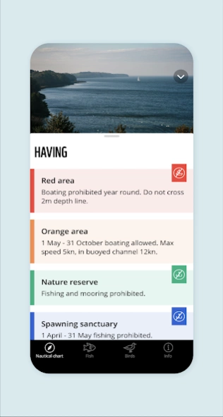
- Orange and red areas indicate when boating is permitted in the area or not.
- If the boat crosses the boundary of a restricted protected area, a message automatically appears on the map.
- Coloured areas provide information about the protected areas (including nature conservation areas and fish sanctuaries).
- Minimum sizes and seasons closed for fishing: during the season when fishing is not permitted for a species, a crossed-out fishhook appears next to the fish.
- Winter sanctuaries, fish and spawning sanctuaries are only shown on the map during the period closed for fishing.
- Use the layer icon to show and hide the areas for boating and fishing.
Have a great day out on the water! Enjoy your visit and please respect nature!
Previous Versions
Here you can find the changelog of WWF Nautical Chart since it was posted on our website on 2024-03-29 22:11:06.
The latest version is 2.0.1 and it was updated on 2024-04-22 13:13:12. See below the changes in each version.
WWF Nautical Chart version 2.0.1
Updated At: 2023-06-26
Changes: The app has been expanded to include the area of Wismar Bay - incl. the voluntary agreement.
The nautical chart has been improved and now has a dynamic display. Detailed maps for the Wismar Bay and the Bay of Greifswald can be downloaded as needed.
The layer icon can be used to fade in our out the areas for boating and fishing.
A bird list with bird calls has been added.
More fish species have been added.
Disclaimer
Official Google Play Link
We do not host WWF Nautical Chart on our servers. We did not scan it for viruses, adware, spyware or other type of malware. This app is hosted by Google and passed their terms and conditions to be listed there. We recommend caution when installing it.
The Google Play link for WWF Nautical Chart is provided to you by apps112.com without any warranties, representations or guarantees of any kind, so access it at your own risk.
If you have questions regarding this particular app contact the publisher directly. For questions about the functionalities of apps112.com contact us.